New Hampshire – Mount Washington
 Spanky and Me Upon Completion of Our Toughest Assignment To Date
Mount Washington is the “real deal,” the “real mccoy,” the “genuine article,” the “granddaddy of em all” (in the eastern US anyway). At 6,288 ft it is the third highest peak east of the Mississippi (behind Mount Mitchell, NC, 6,684 ft and Clingman’s Dome, TN, 6,643 ft). It may be third in elevation……but it’s character, appearance, it’s outrageousness, and sheer audacity, far surpasses it’s altitudinally (it’s not a word – I just made it up) superior brethren.
Why is that, you ask? Let me just tell you. Mount Washington is renowned for having “The World’s Worst Weather.” On April 12th, 1934, the wind was clocked at 231 mph. That’s the highest surface wind ever measured anywhere on the face of the planet! The wind at the summit exceeds hurricane force for an average of 110 days out of the year. Snowfall on the mountain top averages 21 feet a year. During one continuous 71 hr period from January 13th, to January 16th, 2004, the wind chill never got above 50 below! The summit lies hidden in the clouds for at least 60 % of its existence. Had enough yet? It’s a bad ass mountain.
The weather up there is so screwed up as a result of a combination of several natural phenomenon. Washington lies in some sort of a convergence area of Northern Pacific, Atlantic, and Gulf weather patterns (that’s what I read). On top of that, the Presidential Range (of which Washington is a member) has a north south orientation. Atlantic lows create a sucking of air from the northwest, zinging it at super sonic speeds across the ridge of the Presidentials (the Bernoulli effect).
I really don’t know exactly how far away we were, the road twists and turns all over the place, but I’ll say 30 miles for the hell of it, when we first spied Mount Washington (it was hidden in the clouds for the next three days) off in the distance. Of course it’s big, way up there, but what really distinguishes Washington from other eastern mountains is that there is vast barren, rocky area rising approximately 2,000 feet above the tree line. Due to the extreme (almost too mild of an adjective) weather, no trees grow on this good old boy above 4,000 ft. It’s quite a site!
Spanks and I knew that we were in for a formidable challenge. I read stuff in books, checked out numerous web sites, and talked to as many people (who might have some knowledge of the place). The resulting info was unclear. I found at least one web site that said don’t even think of taking a dog up. Some of the folks we met that had been up Washington said no problem with the dog thing (I came to realize that unless you’ve actually done it with a dog, you really have no basis for making that judgment). Advice on which trail to take was also mixed, contradictory, iffy at best.
We decided to do our own recon before we put a plan into action. Spanks and I drove up the Mount Washington Auto Road – a fairly narrow, twisty, some paved, some dirt, no guardrail, with some nice drops offs if you screw up, climbs over 4,000 ft over 8 miles, road. Somewhere around the tree line we got up into the clouds – visibility was maybe 30 ft. We crawled to the top – temp was in the low 30’s, 40 plus mph winds, visibility – nil.
We ended up going into the Tip Top House, a restored hotel that was originally built in 1853. Now when I say hotel, don’t start thinking about the Hilton. It’s a small, single story stone structure with a parlor, a dining area, and a bunk room out back. So, there is this older gentleman in there – he’s kind of guide, caretaker, etc. He’s been around since before they invented dirt. The guy has no problem with me bringing Spanky in out of the cold – a dog guy – as a matter of fact Spanky was also allowed in the coach station building. The whole place is dog friendly.
Me, Spanky, the older dude, and another guy (Tom from Ottawa – hooked us up by taking pics of me and Spanks) chit chat for a while. The caretaker guy tell us all kinds of stories, history, about some chick named Lizzy Bourne that died of hypothermia in 1855, and all kinds of other good stuff. It was great. Spanks was getting petted and scratched and I was getting the scoop from a genuine old timer – and it was nice and toasty in there. But……….most importantly, this guy was savvy to the abilities and needs of a pooch – he gave us a trail recommendation. All the crap we read and researched, not for naught, but in the end, as I’ve said before, talk to a local!
In the end, virtually anyone get to the top of Mount Washington, drive (unless you have an unreasonable fear of heights), or take the Cog Railway. Getting to the summit by hiking and climbing is a whole other proposition.
At the risk of sounding self congratulatory, self applauding, grandstanding, etc, I need to make a statement about how dangerous this mountain can be. Why? The number of recorded deaths on Mount Washington rivals the lives that Everest has claimed (see http://www.mountwashington.com/deaths/index.html for details). As the web page explains, “Most fatalities can be attributed to the mountain's harsh weather in some way.”
I don’t want anyone that reads this to arrive at the conclusion that some clown and his dog just romped their merry way up the mountain……and to get hurt as a result. You must be prepared. For those of you that know this stuff, please bear with me.
First of all, you better be in shape – I’m no world class mountaineer by any stretch, but this is a “strenuous” endeavor.
Secondly, have the proper equipment – all of the following are a must:
Detailed trail map (it’s pretty damned easy to get lost – especially in close to zero visibility)
Water – at least a quart per person (in my case a quart for Spanks as well – but the lad helped himself to stream water along the way)
Warm clothes – water proof (or water resistant) and windproof outer layer, a fleece or sweater, gloves, hat. It can be sunny and 60 or 70 degrees at the bottom, raining or snowing and below freezing at the top – yes, even during the summer. Hypothermia is a killer and it can set in quickly.
First Aid Kit – a slip of fall on the rocks can result in a wound that needs attention. Or you may need to help a fellow hiker.
Last, know your limits. If you get exhausted, encounter a section of trail that is too difficult, or it’s getting too late in the day to make it, turn back. I’m stealing this quote (it’s a famous climber and his name escapes me at the moment). “Getting to the summit is optional, getting back down is mandatory.”
Footnote for Dogs, know your dog’s hiking and rock scrambling ability. In Spanky’s case, he had to endure hopping up rocks several times his size, jumping from one rock to another, etc for hours on end. And……..if your dogs paws aren’t conditioned (Spanky has been doing a lot of hiking) he or she will end up with cut up bloody pads – you may have to carry the dog.
People don’t believe this stuff. They just frolic their merry way up in a t shirt and shorts, get sweaty and wet, and all of the sudden find themselves in freezing cold wind, extremely uncomfortable at best, hypothermic and dead – worst case scenario.
OK already! Enough with the serious crap. This is meant to be fun. So let’s get on with it. Me and Spanks got up at 4:30 a.m. on Sunday, July 1st, 2007 for our attack on Mt Washington. This far north and east, there is already a glimpse of dawn at this wee hour. The first thing I see when I leave the trailer is our friendly, neighborhood black bear. He sees me and takes off (my first ever real live bear encounter). A short while later I caught him again, this time rummaging through a trash can. Off he skedaddled again – probably to another unsuspecting garbage can.
By 7 a.m., Spanky and I were headed up the Tuckerman Ravine Trail at the base of the mountain. It was partly cloudy, about 60 degrees, warm enough that I was sporting just a t shirt (all of the above mentioned gear was stowed away in my backpack). The top of Washington, starting at about tree line, was shrouded in thick clouds (that did not change all day).
This early in the day, there weren’t a lot of people heading up. We saw more folks coming back down. Lots of hikers spend the night in a shelter at the bottom of Tuckerman’s Ravine, where they set up camp and hit the summit early the next morning. One dude made sure he told us, “It’s freaking windy as all hell up there.” Great!
The hike/climb up is a total of somewhere around 5 miles, with a gain in elevation of 4,270 ft. The first half of the hike is really not that bad, a decent, steady incline, get’s the lungs and legs working, definitely worked up a sweat. Me and Spanks chatted with some of the hikers, a husband and wife with their three boys from Massachusetts – the guy told me how he liked to do lot’s of outdoor stuff with the boys. Camping, hiking, fishing, etc, “Keeps em out of trouble.” We also talked with a couple (the female fell in love with Spanks – they all do – I wish I was him sometimes) that we’d end up seeing on the summit a couple of hours later.
Per the previous day’s recommendation (from the old timer) Spanks and I broke off on to the Lion’s Head Trail – “Better for the dog.” It got real steep, real fast. One of the books I read recommended caution so as not to dislodge a rock that can hit someone below you. A couple of lift ups (by me) for Spanks, a lot of sweat for me, and we broke out of the trees into the alpine area, just below the “Lion’s Head” rock formation. Good news, bad news, we got up the steepest part no problemo, but……….we are now in the clouds, it’s windy as hell, and cold (we’d find out later that with the wind chill it was about 15 degrees and the winds were gusting up to 65 mph at the summit)! However, as I pointed out, we are prepared – Spanky has his fur and I had my fleece, gloves, hat, and rain/wind jacket.
Oh, and this was kind of neat. As we were climbing Lion’s Head, we ran across a lady, by herself, that was moving up a step at a time, rather slowly but with purpose. She was no youngster and didn’t appear to be very athletic but she announced to us, “I’ve been training for this since January and I’m gonna make it.” I’ll bet she did make it – I love stuff like that.
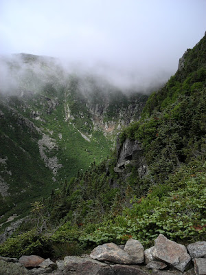
Fortunately, the clouds were just high enough so we could see down into most of Tuckerman’s Ravine and grab some photos. Tuck’s is famous for it’s spring skiing. Ski yahoos from all over the place (I have yet to do it – but I will) hike up in late spring to ski down this monster. The headwall to Tuck’s is steep! A future challenge!
After we passed Lion’s Head, the visibility just went to hell in a hand basket. No views whatsoever – so no pics from about 4,000 ft up. All we could see is the next maybe 20 or 30 yards of rocks (Mt Washington is often referred to as the “Rock Pile”) ahead of us – the line of sight decreased steadily as we got closer to the summit. And wouldn’t you know it, just to add to our pleasure, it starts snowing – don’t forget, it’s July 1st – what’s up with this place. The snow never really accumulated much but it did make the rocks a little wet and slippery.
Basically, the last 2 miles of our climb was spent stepping and or hopping from rock to rock, climbing a few boulders, using rock cairns (piles that marked the trail) as our guide. Not being able to see our goal at all made it interesting, at times tedious, but fun……..it’s actually really cool to be high up on mountain at the mercy of the elements.
Finally, at just a hair over 4 hours, me and the Spankster, stood together on the summit of Mount Washington, all 6,288 ft of it!
At this juncture, we were both a tad chilly and tired so we retired to the mountain top stage building (you can ride up in a van – they call it a stage) and store. Well, it ended up like a little party in there. Spanks of course was welcome inside. A few seconds after we arrived, the couple we met earlier (around half way up) came strolling in. Everyone is petting Spanky, we talk about the experience, the store and stage people tell a few stories, Spanks and I eat some jerky and drink some water, a good time was had by all.
Thanks for dialing us up!

At Treeline, Just Below the Clouds

Another Shot From Below the Clouds

Spanks Rests Up to Deal With the "Rock Pile"
"Tuckerman's Ravine"
 The Day After - A Rare Glimpse of the Whole Mountain
Our Route Was Up the Ridgeline From Left To Right

7 comments:
Great story! Thank you for taking me to a place where it’s cold and windy. It’s been hot, humid, cloudy and rainy here in Florida. Did I mention that it was hot? The Spankster is becoming quite the mountain dog. That’s so cool. You must be proud! I’ll bet you guys slept good that night.
Kenster,
Thanks man. We enjoyed it.....you are correct, we slept pretty soundly that night - after a few pounds of grilled cow!
Wow, what a great adventure! Loved reading the detail and background. Better check with Mateo on that Bernoulli thing though. Ever onward!
KAVSMANDU,
Thanks for you kind comments. Did you notice on all the New England pics how verdant everything is?
Reinman and the Spank man, you guys are amazingalotamis. Really enjoyed the story. When I lived nearby Mt. Washington you always heard stories of people getting stuck up there, no poop people it is very unforgiving. Stay well Seeeeeya, Rick
Rick,
I'm getting jealous - you're better at making up new words (amazingalotamis) than we are! Thanks for the comments!
Ed Viesturs said the "getting down is mandatory" quote.
Post a Comment