Maryland – Backbone Mountain

Spanky Puts Another Notch In His Collar
Totally shaken up by our near death experience on Ebright Azimuth in Delaware, Spanky and I needed a few hours to physically recover and gather our senses. Actually……we stopped for gas, checked our computer generated directions vs the trusty Rand McNally Road Atlas, broke out some beef jerky, got a fresh coffee, Spanks drank some agua, and we took off down the pike for Maryland.
The big plan was to camp out at a KOA campground in Hagerstown, Maryland for a couple of days. Reason being that Hagerstown was within fairly reasonable reach of Maryland’s highpoint as well as sorta on our way to points west (PA and OH) and additional summits.
The Hagerstown KOA sits in a rural river valley. Good thing about all KOA’s is that there are highly legible and visible signs that lead the camper for the final few miles. So, off the interstate, onto a few back roads, turn right at an old mill, and up a narrow access road that follows the river. The torrential rains over the last few days had swollen the river to a muddy torrent that threatened to cover the road. Fortunately the deluge had abated and we didn’t have to worry about being stuck in the woods with no way out (visions of Deliverance dancing through my head).
The first order of business is to take care of the Spankster. The poor lad has been stuck in the truck all day so we need to explore and find out where he can get some good running time in. Aha, a path up the hill into the woods right behind our campsite. Tail a waggin we go up the hill. Spanks does his usual running around, sniffing up a storm, and nosing around in piles of dry leaves (guess he likes the sound of leaves crinkling – also a favorite relief area for him).
We nose around for a while, go up a dirt road for a bit, and head back down the hill into the woods on a different path. Just off the top of the hill we stumble on a grave site. The grave is surrounded with rocks, an angel sitting at the food of the grave, and a simple headstone, “In Loving Memory, Tyson.” There is a paw print on the headstone. Someone has buried their dog here and honored him with a formal grave and headstone. Spanky and I take a moment pay tribute – these folks certainly loved their best friend, Tyson.
The following evening I actually got the story on Tyson the dog. I was in the KOA office talking to the owner lady and mentioned that Spanky and I found a dog grave up in the woods. She sadly smiled and told me that it was their dog (passed away last summer – I think). Poor Tyson got cancer at the age of seven and didn’t make it. She said they were devastated and felt that she needed to keep his memory alive with a proper grave – a place to honor him, a place to meditate and reflect. I can totally understand. In any case, this little story speaks volumes about Tyson’s owners and of course Tyson. Hats off to you guys!
Now, for the Maryland summit story. I usually try to get some last minute info on each summit off the net. There are numerous sites where people have related their experiences, specific directions, even maps. Unfortunately, the KOA’s satellite internet connection had gone south. Apparently Hughs was not being all too cooperative about getting it fixed either. So I resorted to Microsoft Streets and Trips, which is great for getting from point A to B but lacking on final summit approach roads and with zero trail info. But it was all we had so……that had to be good enough.
On the morning of April 18, 2007 we took off for Backbone Mountain, Maryland’s highpoint, approximately 120 miles away. About half the drive was west on I-68, one of the most scenic interstate drives around. Our journey then took us south west, in and out of West Virginia, through rural little burgs, over hill and dale, and through a hollow or two. This is coal mining country and there is quite a bit of evidence of coal mining’s impact.
The Eco Nazis of course would find any sign of mining activity to be an atrocious misuse of our planet’s resources. Hey, I don’t like it either but I’ve gotta remember that we all use electricity and coal is still burned to generate power. Over time (and we are making progress) we will find the correct balance between man and the environment. I just don’t care for the hypocrisy of people screaming about not burning fossil fuel, saving the rain forests, (Hollywood types, many politicians, and other people of fame and fortune) when they themselves are conspicuous consumers – driving big ass SUV’s, heating huge homes, jetting around in private planes, etc.
A little humorous note. I believe we were just about to cross the Maryland/West Virginia border, coming down a hill, and we spotted an eatery on the side of the road called the “Chat and Chew.” It’s a shame that we had summits to climb, otherwise we would have most definitely stopped for a little chattin and chewin.
After a few hours of driving we finally found a little road called Gnegy Church road – our last paved road of the day. We followed this quaint little country cart path until it ended. No signs. A 4wd road took off to the right, hmmmmm, according to my directions a right was appropriate. So I slammed the truck into 4wd and gave it a shot. A few hundred yards is all we were good for. The road was covered in snow, mud underneath, and periodic little canyons where streams had decided to eat away the road. Too sketchy! If we got stuck, no one around to pull is out. So we get out and hoof it.
Spanks and I slosh through the slush and mud maybe a half mile up the mountain. From here it becomes guess work. There is a fork in the road. As Yogi Berra once said, “When you get to the fork in the road, take it!” We went to the right – looked like that was going higher than to our left. Meanwhile, Spanky could care less where we were heading. He was having a grand old time playing gallop through the snow drifts like a leaping gazelle. Did I mention he was smiling?
We slog up to the highest point to the south – no signs of a highpoint here – no markers, signs, no tracks. Can’t be the right place. Maybe that other peak to the north is it? We trek up that way. Nope, not it either. I’ll bet we did a few miles back and forth, trying to look for a sign of some kind. No luck. But being the steadfast, goal oriented adventurers that we are, we ain’t quittin now.
Me and the Spankster make our way back to the truck and go in search of information. We get back to the main road and find a general store in a little town that consisted of just the general store and a couple of houses. There is a guy wearing camo standing outside smoking a cig – I ask him if he knows how to get to Maryland’s highpoint. The dude totally hooks us up! He tells me to head down the road (opposite direction of where we came from) for a little over a mile, “On your left, just past a white house, Highpoint will be painted in orange spray paint on the backside of a road sign. Just head up the logging road and you’re there.” I’ll be damned if that wasn’t the case.
We find the sign, park the truck (the logging road is not drivable plus it’s a private coal company road), and go back to slogging through the slush, mud, and rivulets, up the mountain. My feet are soaked (goretex is only good for so long), I’m a little tired from our previous attempt but Spanks is enjoying the hell out of it as usual. This time the trails are marked (HP – Highpoint) with orange spray paint on trees to indicate the correct way to go. Somewhere around a mile later, me and Spankster conquer another summit - 3,360 ft above sea level.
The weather is still crummy. Fog blankets the mountains and valleys all around us so there is not a whole lot to see in the distance. However, we are in the woods, task accomplished, it’s peaceful as all hell, it’s all good.
The local name for Maryland’s summit is Hoye – Crest. It is named after (as you can see in the pic) Captain Charles E Hoye, founder of the Garrett County Historical Society. He is also an author who has written several books about the pioneer families of Maryland.
Spanks and I take a few pics – limited due to the weather and meander on back down the mountain to our faithful horseless carriage. It was a great day! Getting a little confused over where the actual summit was no big deal. We got to do a whole bunch of hiking together, Spanks got to wear himself out frolicking in the mud and snow, and we nailed another summit. It was a most excellent adventure!
Back at the campground, tired and hungry, both Spanky and I thoroughly enjoyed a meal of turkey burgers cooked up on the camp stove. I think we hit the hay around 9 pm. What could be better – tired, full stomach, camping with your dog, and the two of us dropping off into a sound slumber dreaming of summits gone by and summits to come.
Until next time!

Me and Spanks At The Summit Marker

View From The Summit Shrouded In Fog
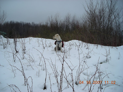
Spanky Looks For The Trail

The Summit Marker
And Then - A Few Days Later, The Sun Comes Out

Spanky Basks In A Sunny Pennsylvania Meadow

Followed By Chillin In a Woodland Stream

5 comments:
Hey Spanky-
Them orange arrows are sure difficult to follow aren't they?
A long overdue "BLOG" to my dear friend REIN and the SPANKSTER! I can't begin to tell you how much I am enjoying your adventures! I especially loved the story about attending your friend/former boss 92nd birthday party! How cool to catch up with "old friends" and share those "blasts from the past/Estonian camaraderie!"
I am assuming Frank from NJ is "our Frank" no pics?
We miss you and THE SPANKSTER! Hi from Nort! Safe Travels!
LOTS OF LOVE! SAL
I guess you forgot to bring your government issued CIA/NSA/MIA/FDA/NASA certified GPS on this trip. This sounds like your most challenging quest to date. I hope you weren’t relying on Spanky to guide you, you know dogs are color blind. Pics are cool and we’re all glad you conquered another summit.
I found this from a link in a Marc Fisher WashPost article. Interesting access issues you ran into, I may have to try this hike next time I'm Garrett County. While it made things rough on that day, snow in April warms my heart on general principle, it's just warm enough in Alexandra during winter so anything falls as ice.
I'll have to check out your Connecticut trip; I think it's hilarious that the highest point in the state is on a mountain with a summit in another state. I've also been to the highest points in NH, VT, and MA (Greylock is like a mini rain forest near the base).
Dear Maryjanejeff,
Thanks for your interest in our blog.
Spanky and Rein
Post a Comment