South Carolina – Sassafras Mountain

I’m sitting in the trailer at 3 a.m. awake, got a raging headache, mega thunder claps are echoing through the mountains, every few seconds the whole world seems to light up with lightning, the rain is pounding the trailers aluminum roof – sounds like buckets of glass pellets are being poured on us, Spankster is a little nervous about the whole thing, but………..otherwise life is grand!

Oh well, can’t have perfect conditions every day of the week. After comforting the boy (Spanky) until he managed to doze off again I figured what the hell, might as well do a little writing – tell the tale of the heights of South Carolina and our 7th summit.

We took off from Enota Campground at about 7 am on April 3, 2007. Sassafras Mountain is only about a 100 mile drive from Enota but we wanted to stop at the coffee shop in Hiawassee to take advantage of their wireless access and update y’all with our ongoing saga. Spanky patiently waited in the truck while I slugged down an Appalachian Trail Blend (lots of hikers come off the trail to stop in Hiawassee) with a shot of espresso added to goose up the caffeine and scarfed up a parmesan cheese bagel.

Me and the Spankster figure a couple of hours to do the 100 miles. No, wrong again! Remember we are in the Appalachian Mountains, no interstates, rough mountain driving, slow speeds, spring repairs and roadside vegetation clearing is being done (we had to stop and wait for one way only spots about 4 or 5 times). So it took four hours – oh yeah, I passed our final turn off so a little back tracking was involved also.

It’s been a long time since I’ve really been anywhere in the Appalachians. Most of my mountain traveling in the last 15 or so years has been out west (Rockies, Sierras, Tetons, etc) and I had forgotten that even though there is no comparison (east vs west) in elevations, there are some serious mountains in the east.

OK , bear with me, I must go into a short discourse on the Appalachians (I find this crap interesting – hope at least some of you do also). The Appalachian Mountain Range extends all the way from Newfoundland, Canada down to northern Georgia, Alabama, and even Mississippi (foothills). It encompasses the White Mountains, Blue Ridge, Berkshires, Taconic, Great Smokys, just to name a few (many folks think of these as separate and distinct ranges but they are all part of the Appalachians).

These babies were formed somewhere around 300 million years ago (Rockies about 100 million) so they are old and worn down by the forces of nature (rain, wind, glaciers). The range resulted from major league tectonic plate collisions that formed the super continent Pangaea. The resulting Appalachians being approximately at the center of the continent.

What was my point? Oh that’s right, the driving was rough. Up and down, constant sharp curves and switchbacks back and forth. Poor Spanky couldn’t even catch any zzz’s. The constant turning and bouncing was tossing him around in his seat (the passenger seat of course) like a rag doll, he ended sitting with his front legs held out to brace for the constant turns and braking.

The payoff, however, was that we were constantly bombarded by some of the most picturesque views you could ask for. It is spring and everything is turning bright green – the trees, grass in the valleys, farm pastures. We got to peer down into countless valleys, always with more mountains as a backdrop, the spring runoff is feeding scores of waterfalls cascading over cliffs and huge rock faces, we drove through dense rhododendron forest spotted with moss covered rocks and boulders, around almost every turn we were treated to another postcard image, it was really cool! I know, I should have stopped for more pics but……..when I’m on a mission not much of anything slows me down till I get there. Besides, we have lots and lots of photo ops in our future.

Our route took us out of Georgia, through southwest North Carolina and then to just across the NC/SC state line to Sassafras Mountain. Sassafras tops out at 3,560 feet. So it was kinda anticlimactic. Hell, we’d driven through at least one town, Highlands, NC, with an elevation of 4,100 feet. But, Sassafras is the South Carolina summit so it is significant to meeting our goal.

I must mention that somewhere along our journey to Sassafras, in the middle of nowhere, we saw a combination country store, bar, video store, tanning salon, and if that’s not enough for ya, they have karaoke! I don’t know about you but that just sounds like almost too much of a good time. Spanky and I decided to try and make it back there someday. With all that stuff going for them that business should last a long time.

Anyway, we finally get to a small parking lot which is a short walk from the top. Spankster is itching to get out of the truck. There were some young folks (two couples – I think – college age?) having lunch at the edge of the parking lot. Spanky immediately ran over to them to introduce himself. Spanky loves people but the fact that they were eating made his mission all the more important. He figured that the lunch had been prepared for his arrival. Spanks and the kids had a nice visit. Turns out they were also on a mission to hit several state summits. Yes, there are other yahoos out there that do this stuff.

We made the short walk, all of about a few 100 ft, to the top. Summit number seven completed! There is really not a lot going on the top of South Carolina – which quite frankly is the way we like it. No fanfare, no observation tower, no visitor center, no hot dog vendors. All that poor old Sassafras has to tell us she’s there is the USGS marker set in concrete. The top is well rounded and heavily treed so there really isn’t much of a view. But, there is tons of room for Spanky to do the now famous, often imitated, soon to be copyrighted Spanky Mountain Top Boogie. The boy just loves to run around, seemingly without purpose, nose to the ground tingling from an overdose of olfactory delights, tail going a mile a minute, smiling all the way.

Don’t get me wrong, Sassafras is a pretty spot. Me and the Spankster thoroughly enjoyed stretching our legs and chilling out in a nice quiet natural setting. We took a moment to partake in a little of our favorite traveling snack, beef jerky, drank down some water, did a little exploring and headed back to the old truck.

The young folks were still having lunch down in the parking lot. Spanky took a moment to wish them a safe and prosperous journey (he was still trying to grub some food – I can see through his act). Upon bidding farewell to the mountain we set forth on our journey back to our temporary home at the Enota Campground in Georgia. We took a slightly different route on our return. Won’t bore you with the details but suffice to say that nature treated us well.

One thing I will add. Most of the area that we drove through today is extremely rural. As a matter of fact, the word wilderness comes to mind. However……..and that is big however, one is confronted unexpectedly, in the middle of nowhere with big ass new houses, no, mansions, lodges, what ever the hell you want to call them. I’m no rocket scientist but I’ll bet property values are spiraling out of control. It’s a shame but I guess that’s progress, or is it?

Spanks was happy to be back, happy to get the hell out of the truck, happy to see his new friends at the campground, and most importantly happy to see that I was starting to cook up some chow on the old grill.

Another good day!

Me and Spanks On The Summit

The USGS Summit Marker

View From The Summit Marker

Camping at Enota

What the hell is an Enota? Actually the common spelling is Enotah and it is the Cherokee name of Brasstown Bald (Georgia’s highpoint) which is just over yonder. I like it, it was a good choice for naming the campground. I tried to find out what Enotah means in Cherokee, even found a Cherokee to English Dictionary but no luck.

Get ready, I’m going on a short rant here. So, this area is chock full of towns, mountains, rivers, lakes, etc with Native American (mostly Cherokee) names. But…….I don’t see any Cherokees just mostly white folks of European descent. Hmmmmmmmm, something must of happened to the Cherokees.

Hell yeah it did. A couple of hundred years ago the white man came up with this brilliant concept called the Treaty. These clowns somehow concluded that they were more deserving of the rights to the land than the people that lived here in the first place. So they coerce “tribal representatives” to sign treaties where the natives agree to give up their rights to beautiful, heavily forested, fertile hunting grounds in exchange for a nice piece of desert. This is a deal that any telemarketer, televangelist, flim flam artist, or con man would be jealous of.

According to the little bit of reading I’ve done, at least in the case of the Cherokees, the dudes that signed the treaty were not authorized to do so nor did they by any stretch represent the tribal conscience. No problem, the Cherokees were just forcibly lead out of town (one of our more well known presidents, Andrew Jackson, had a hand in the forceful “relocation”).

There is a lot more to this story but suffice it to say that the whole deal pisses me off. As we travel around this area (all of the east coast actually) I periodically start thinking about the natives that lived in harmony with nature until we showed up, took it from them, proceeded to cut down trees, bulldoze, build, pollute, and generally rape the land. I know, I know, this is somewhat hypocritical of me – I’m one of the white guys that lives here and takes advantage of all this stuff. But I can’t help but wonder if somehow we could have coexisted, come up with a better deal for all concerned – something to ponder.

Anyhow……we arrived at Enota Campground on Monday, April 2nd soon after summiting Brasstown Bald. Remember we are in the woods, there is nothing on the sides of road except trees and mountainside. The Enota sign just kinda blends in with the surroundings but since it is one of the only roads around we find it pretty easily. We proceed onto a dirt road that just seems to go into the forest – I’m thinking is there really anything here?

Ah, I spy a few tents, some travel trailers, a few RV’s, but not on top of each other. There are lots of trees, I see at least one stream, a pond and finally a log cabin lodge/registration area. At first glance this looks pretty cool, it’ll do just fine. Spanky is all eyes and ears, there are a couple of small doggies on the front porch of the lodge that get his attention, the boy is excited.

The lodge is really neat. There is nice big sitting area with couches and chairs in front of massive stone fireplace, looks real cozy. I get registered, which means they just give you a little map of the place and draw a circle around your camping spot. The guy that I made the reservation with over the phone comes out, he remembers talking to me. I start asking him all kinds of questions like a dumb yankee checking into a hotel, he politely listens and says, “Why don’t you just take your time, get set up, take a nice walk around the place, you’ll figure it all out.” He was right. Nice friendly people. Something tells me that this place is kind of hippyish, commune like, turns out I’m right about that. It’s actually a good thing.

We find our spot and it is wonderful! There is a stream right behind our designated area. The stream is surrounded by rhododendrons, the water is sparkling clear, and there are some ducks making their way up stream – you guessed it, the ducks immediately get Spanky’s undivided attention.

Spankster immediately introduces himself to the people camping just uphill of us. Their son and another little boy are running around in bathing suits and manage to get Spanky into the stream. Spanks is having a great time from the word go. Yep, this place will work out just fine.

Couldn’t have been more than five minutes after I got the trailer unhitched. A lady, Miriam, and her son, Bret, come walking by and Spanky catches their interest. It is immediately obvious that these are dog people. Miriam and Bret instantly befriend Spanky and as it turns out will spend a ton of time with Spanks over the next couple of days.

Miriam is a special ed teacher. She has two adopted sons. Bret is from Guatemala and he is eleven. Her older son is fifteen and is from Paraguay. She is a widow. Her husband was a cop that died of cancer. I think I got the story straight, if not apologies, but after her husband died she decided to adopt the boys. If Bret is any indication, she is doing a spectacular job. He is one of the most well behaved, polite, friendly kids I ever met.

Miriam is waiting for her neighbors to show up. As luck would have it, her neighbors end up in the camping spot on the downhill side of me and Spanks. Over the next few days the neighbors, Wayne and Sharon and their kids, Zane, Zach, and Noel, and of course, Miriam and Bret, all would become part of Spanky’s extended family. Man did Spanky luck out (so did I). Spanks probably spent as much time at their camping spot as ours. He was fed burgers, snacks of all kinds, even got bacon and eggs for breakfast one day. Could not ask for a nicer bunch of folks.

Enota Campground is big! It consists of 60 acres of land that contains the camping area, the lodge, multiple mountain streams, several ponds, a working farm, quarters for workers, a playground (with trampolines) for the kids, lots and lots of trees, and it is surrounded by mountains rising in all directions.

It is actually a not for profit organization. As I understand it, Enota’s goal is to have a self sufficient, totally organic, ecologically correct working farm. The camping fees help fund working toward this goal. There are also a bunch of folks (seems to be mostly college age) working as volunteers in exchange for room and board. It really is kind of communal – see I told you the place had hippies! All kidding aside, I believe it’s a worthy goal. Sure beats the hell out of chasing the buck and dealing with the rat race every day of the week.

All this space provided Spanky with an almost unlimited playground. He ran for hours on the grassy fields adjacent to the farm (most excellent fetch the stick area), jumped in and out of the streams to chase ducks or just for the heck of it, took several hikes up the mountain, played with the kids in the playground (one day he had at least half a dozen kids chasing him while he played “run around in huge circles”), enjoyed taking walks through the camping area, and just generally had a blast.

When back at the trailer Spanky usually was being spoiled by the neighbors (alright – he was spoiled to begin with). I think every kid in the place new his name. They’d come by the trailer and ask if they could play with Spanky. Of course Spanky did his doggie duty and allowed all comers to pet him, scratch his stomach, etc (you know he was digging it).

At dinner time Spanky always managed to slink on over next door. Wayne and Sharon, Zane, Zach, Noel, and of course Miriam and Bret treated Spanky like gold. He scored some big time hand outs and lots of love from these folks. Thanks guys, for helping to make our stay a really great experience.

We only sampled it but judging by our experience there are some tremendous hiking opportunities directly out of the campground. Spanks and I took one day off from summiting just to check it out. We managed to hike/climb to two really beautiful waterfalls and we followed a trail several miles further up the mountain to the Appalachian Trail.

The Appalachian Trail is 2,174 miles long, extending from Springer Mountain, Georgia all the way to Mount Katahdin, Maine. The AT has shelters (about a day apart) all along its length. It is well marked and maintained. If that isn’t a spectacular hiking opportunity in your back yard!

Spanky is turning out to be quite the hiker. He knows to stay on the trail, usually stays pretty close in front or behind me, does a great job scrambling up steep, muddy, rocky stuff (although he did take a spill slipping on a moss covered boulder), has no problem fording streams, and never seems to wear out. Hmmmmmmm, a future adventure, the Appalachian Trail?

In conclusion, Spanky gives Enota the official Spanky seal of approval. I kinda liked it as well. If you are ever in this neck of the woods and want to have a great camping experience, check it out.

Our Neighbors and Spanky's Friends, Zack, Bret, Wayne, Miriam, and Noel

One of Many Fine Waterfalls

Spanks at the Playground with Bret, Zack, Noel, and Zane

I call this one "Spanky With Stick On The Farm"

The Stream Behind Our Trailer

The Lodge

Spanky's Duck Buddies

Another Waterfall Close to the Campgrpound

Tennessee – Clingman’s Dome

"Hey Dad, We Made It to the Summit"

Me and the Spankster got pretty chilly last night. It got down to the upper 20’s and to top things off we lost power for somewhere around 3 hours. I do have a little heater which warms the trailer a wee bit but without power it got cold fast. Spanks and I huddled together in the sleeping bag to keep each other warm until the power came back on and Spanks settled back into his accommodations (blanket on the floor of the trailer).

Clingman’s Dome, the highest point in Tennessee, is about 100 miles from the campground (one of the reasons I picked this place – we could make day trips to several summits). We set forth early on the morning of April 5th to nail another one. The air was cold but the sky was blue and perfectly clear, a fine day to meander through the Appalachians on up to Tennessee.

This particular mountain tops out at 6,643 feet. We are starting to get into a little more serious elevation here folks. Clingman’s is the second highest peak in the United States east of the Mississippi coming in just a little short of North Carolina’s Mount Mitchell. It is named after this guy named Thomas Lanier Clingman who extensively explored the area back in the 1850’s. It is located in Great Smoky National Park which made me a little wary cause National Parks have really strict anti dog laws. We need to start a Doggie Constitutional Rights Group or something.

Driving to Clingmans was quite a bit easier than our drive to Sassafras, SC. The roads are newer and thus in better shape with far less extreme turns. The drive took us up and down, through gaps in the mountains and as you would expect, spectacular Appalachian scenery.

Coming from the south, just before entering Great Smoky National Park we were treated to the (in my opinion) terribly tacky town of Cherokee, NC. What a tourist trap. There was a roadside “Pan for Gold” place, a bunch of “Discount Souvenir Shops”, cheap “View the River From Your Balcony” motels, “Genuine Native American Arts and Crafts”, and to add insult to injury we actually saw some people dressed up as natives standing in front of shops trying to lure in the tourists. I think you can guess – we did not stop.

The National Park Service does a fine job. My experience is that they successfully strike a balance between keeping things as natural as possible while making it accessible for public use. Great Smoky National Park immediately gave me that same impression. There is a small stone visitor’s center just beyond the entrance. Adjacent to to the visitor’s center is an authentic reconstruction of an old mountain farm. The structures all just seem to blend into the setting. The 25 mile or so drive up the mountains revealed very little evidence of humans (other than the road), a few small unobtrusive roadside sides, a couple of entrances to camping and day use areas, that was it.

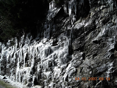
The final drive to Cingman’s is a 7 mile long road that just opened up on April 1st. It is closed from the beginning of Dec through the end of March……..and for good reason. Let me assure all of you that winter is not done with us yet. You northerners may be thinking, Tennessee, that’s the south, it’s warm. Absolutely not! Now, I did say that it was a clear day but at around 6,000 ft elevation we encountered some clouds and guess what? All of the sudden we were driving through snow flurries! Soon thereafter we encounter a cliff face covered in sheets of ice. Conclusion, it is definitely below freezing.

We make it to the end of the Clingman’s Dome Road to a parking lot. There were some pretty heavy wind gust going on, I could actually feel the truck moving. Spanky has a quizzical look on his face, “We’re not going out there, are we?” There were other people up there but most hopped out of their cars, clicked a pic or two, felt the arctic blasts, and got the hell out of Dodge. The parking lot is not the top – we still have a hike ahead of us!

Having spent time around mountains, I knew that since it was cold down below and we were going pretty high up, it was going to be a lot colder up there. Accordingly, I brought a fleece, a ski shell, and a pair of gloves with me. I got dressed, got Spanky out of the truck and we went for the summit. The wind was really assaulting us. Spanky had never felt wind that strong. He didn’t get it at first but quickly got used to it. Hiking up the path (pretty good incline – half a mile long) we hit a spot with ice. Spanky hesitated, he just didn’t know what it was. A few steps and slips and we were over it. The boy strode ahead like a true trooper in face of the inclement conditions. No Dog Police to be seen – we were gonna make it!

The degree of incline, the altitude, and the weather made the short hike a little bit of work. Which is good – the body warms up with exertion. The top! The top of the mountain is rounded (thus the term dome – I guess), the vegetation consists of some really gnarly looking short twisted trees. Heavy wind blasts and harsh cold conditions obviously are right at home here. The scene is reminiscent of some north east mountain tops I’ve been on while skiing. Stunted vegetation, rocks strewn about, and blasting winds conspire together to give summits like this one an other worldly appearance (my opinion anyway).

There were only a few other people at the top. Spanky instantly made friends with them. We ended up exchanging cameras to take a few shots of each other. Too cold and windy for much small talk. As if it weren’t cold and windy enough on the ground, there is a 50 ft high observation tower (big spiral ramp leading up to what looks like a flying saucer) that is absolutely exposed to the elements. What the hell, we’re here, might as well do it. We went up and I must say, “Spectacular.” An overused term but very appropriate here. Pictures were taken very quickly, Spanks was starting to shiver and I wasn’t exactly warm either.

Actually we lucked out. Even though it was bitter cold and windy, the skies were relatively clear. A few stray clouds occasionally depositing trace amounts of snow. Apparently Clingman’s is socked in a good deal of the time. So a little chill is a small price to pay to get the view. Summit number eight – done deal!

On our way home I stopped at the Mystic Mountain Coffee shop in Hiawassee to get some high speed wireless access and a cup of java. The coffee shop lady notices my desktop image which is a pic of Spanks on Destin Beach and asks, “Is that your dog?” I respond, “Yep, he’s right out there in the truck.” She looks and says something like, “adorable, cute, precious.” Hey what about me lady? Just kidding. I started to read my email and before you know it she’s handing me some slices of black forest ham to bring out to Spanky. He pretty much inhaled the stuff. So, coffee lady, if you ever read this, thanks again. Spanky and I much appreciate your hospitality.

Tomorrow morning it’s off to Asheville, NC to stay with some friends for a few days.

Thanks and I’ll update this thing in a few summits. Until then!
Ice Covered Cliff on the Summit Approach
Spanks On Top (Note Snow On Evergreen Branches)
Spanky Checking Out The Weathered Landscape
Summit View - Yep Thats Snow On Peaks Below
They Say You Can See 100 Miles From Up Here

Virginia – Mount Rogers

Spanky On the Mount Rogers Summit Rock

But first, a little about Mount Mitchell, North Carolina

Spanks and I left Enota Campground, our home for the week, on the morning of Friday April 6th. Could have easily stayed in the area just to explore, hike, hang out in a beautiful spot, etc but it was time to move on. Our next destination, Asheville, NC.

An old friend of mine (since we were kids), Jaan, his wife Linda, and their dog Susi, recently sold their home in St Pete, FL and moved to Asheville (actually Waynesville – a neighboring town). As I’ve explained several times, one of the key functions of this traveling circus is to visit old friends along the way. The fact that the highpoint of North Carolina is close to Asheville and an opportunity to stay indoors for a few nights also factored into our planning.

We arrived at Jaan and Linda’s house around noon. Spanky and Susi (the dog) had only met briefly down in Florida. They proceeded to get acquainted in proper doggy fashion – vigorous sniffing, some barking, chasing each other, marking in front of each other, etc. Didn’t take but a few minutes till they were best of friends.

The afternoon was spent doing a little grocery shopping, checking out the area, watching the dogs run around the back yard, culminating with burning up a couple pieces of most excellent cow on the grill. That evening, Jaan built a fire in the backyard (which happens to be on a river – really gorgeous) and we sat around the fire telling tales of our misspent youth, trying to out do each other and, I think, shocking Linda with some of the tawdry details.

OK, so I thought it was springtime. Saturday morning greets us with 4 inches of snow on the ground. What the hell is going on? Winter apparently is not done with us yet. In any case, the snow quickly melted and did not hamper us from doing some sightseeing and looking at real estate. The Asheville area is beautiful! But, being that is such a great place, it has attracted quite a bit of development. Homes (mostly vacation homes) are being built left and right, and prices are going through the roof. Jaan and Linda are unfortunately having a rough time finding a reasonably priced house to buy (they are renting at the moment).

Mount Mitchell (see I got back to the summit thing) can be directly reached off the Blue Ridge Parkway and it’s pretty close to Asheville. Jaan and Linda decided that they would like to be part of the great adventure so we all head out together on Sunday morning. Not so fast! We take the shortest route to the Parkway only to be confronted with a closed off entrance gate. OK, let’s try another approach, closed gate again. Several hours later, trying to approach Mt Mitchell from the east, yep, you guessed correctly, closed gate again.

You know how guys are, we never ask for directions or any info for that matter. We can figure it out on our own! Finally, after three failed attempts, and at Linda’s suggestion, we stopped at a campground/trout fishing place and I talked to a guy that worked there. According to him the Parkway (runs way up on the ridge line of the mountains) is closed cause way up there, they got more than a foot of snow and they don’t plow, they just close and wait for the snow to go away. Wrong! According to the Blue Ridge Parkway site, there is a stretch of Parkway that is closed until the end of this month due to maintenance. Seems like none of the locals are aware of that.

So no Mt Mitchell at this point. But…….Spanks and I vowed to be back soon – we must! Being the flexible travelers that we are, we just left town, bidding farewell to Jaan, Linda, and Susi for more summits down the pike. Lots of you readers out there know Jaan and Linda – check out our visit pics at http://picasaweb.google.com/rkrevald/JaanJaLindaS

Which brings us to Mount Rogers, Virginia.

Based on all the info that I’d found on the net, I figured out that we were in for a fairly significant hike to get to the summit of Mount Rogers. The only problem was that I was kinda sketchy as to which trail(s) to take and exactly where to find them. So….we left our campground early to give ourselves ample time to find the place (at about 7 a.m. on April, 10th on a cold (low 20’s) but sunny morning). Long story short – we talked to a lady forest ranger in the parking lot of the Mount Rogers National Recreation Area Visitors Center who hooked us up with directions to what she felt was the most scenic hike to the top (she was right!). Thanks!

Our approach started from Grayson Highlands State Park (within the Nat’l Forest) at a place called Massie Gap, at approximately 9 a.m. Remember that it snowed a few days ago. Massie Gap is above 4,000 ft and there is still plenty of snow to be seen – northern exposures, in the trees, and on the mountain tops. Me and Spanks looked at the posted maps and figured no problemo – we got it together. Looked like it was gonna be about 8.6 miles round trip and according to what we had read, should take us around 5 hours. We did run into one other person headed up the trail that morning – a dude and his Chocolate Lab – he told us, “Me and the dog are gunna spend a few days in the woods.”

The trail started up through several alpine, grassy meadows. Higher up we encountered some sparse hardwood trees, lots of rhododendron forest, and spruce forest. But for the most part there were just rocks and grass and a lot of remnants of dead trees. Wow, this place was really different looking – and really beautiful! I figured that nature had done this all on her own – not!

As beautiful as theses highlands are, the landscape's original beauty has been altered by, you guessed it, us humans! At one time, every fourth tree in the mountains was a chestnut, but blight killed all the massive chestnut trees in the early 1900s. After the blight, loggers hauled out every available tree for its valuable, decay-resistant wood. About the same time, logging and fires decimated the virgin stands of other forest species. It took the logging companies a period of only 12 years to de-nude the landscape. What nature had given us, we destroyed – an all too often told story.


Due to the severe climate, strong winds, and loss of soil following logging operations, recovery to a natural state is an extremely slow process. That said, it is recovering. Trees are renewing themselves, and a community of hardy wildflowers, shrubs, insects, birds, amphibians, and mammals that can withstand the harsh conditions of the open highlands have adapted to life in the alpine meadows. In the end, the place is different and it is gorgeous beyond words. There are spectacular views in all directions of the valleys below, there are rugged rock outcroppings and peaks, the grassy alpine meadows, dense rhododendron forest in shaded areas, dense spruce forests on many of the summits, it’s just really cool!


So me and the Spankster are on our way up, we cross up over a grassy knoll and lo and behold, wild horses! I quickly put Spanks on a leash – don’t know how he and or the wild ponies are going to react. Spanks spies the horses and stops in his tracks. The horses spot Spanky and me, check us out, lose interest and continue to do horse stuff (eat grass, walk and run around, and leave lots of pasture pastries). Turns out humans had a hand in this also. I couldn’t find much info but……someone turned a bunch of horses loose up here, they have adapted, they are healthy, the heard continues to breed and call the highlands home.


Does not take us long and we are clamoring over some fairly rough terrain. We encounter snow drifts, lots of nice sticky oozing mud (where the sun is hitting – otherwise frozen mud), we have to climb up over rocks, try not to slip on ice (shady spots), the trail actually leads through a cave, it’s not exactly a walk down the sidewalk. As I said, the trails looked simple enough to follow, I did not have a map, and I must admit that I spent a little extra time and distance trying some alternate routes (took a couple of wrong turns). Fortunately my built in compass (actually looking at pics of the place on the net ahead of time) brought us back to the correct route.


For those of you that are interested, most of the hike is actually along the Appalachian Trail but we don’t see anyone (I think it’s still early in trail hiking season) until about 11:30. Two dudes that started in Georgia last month and are hiking through all the way to Maine – remember that’s 2,174 miles – hats off and good luck to you guys!


Our final summit approach (mountaineering lingo thrown in to make us sound like cool mountain type guys) is a one mile spur off the Appalachian Trail. The spur goes up through what starts as mud and snow into dense spruce forest where the trail becomes just ice and snow. These spruce normally grow only further north but the elevation of Mount Rogers provides them with just the right climactic conditions. The trees are so dense that the sun barely filters through.


At 12 noon Spanks (when’s he gonna let me get there first?) and me hit the summit – 5,729 ft. Mount Rogers is a rounded mountain. The summit is a small clearing in the forest where the USGS marker has been embedded in the top of a boulder. Because of the dense forest, there is no view to speak of. However, it is really cool anyway, beautiful green spruce, snow on the ground, and sun shining through onto the summit clearing!


There was actually someone up there ahead of us! A guy named Chris from Boone, NC had camped up there overnight. He’s hanging out in the woods, camping for a few days, on a walkabout so to speak. Chris helps us out by snapping a few photos, we shoot the breeze for a while, he plays with Spanks while I take another few shots, and he takes off for some more out back adventure. Nice to meet you Chris – travel safely!


I’ve gotta admit, I was a little wary of this venture up Rogers. I had no idea how Spanky would do on a half day excursion into cold, muddy, snowy, icy conditions. He’s amazing, he loved it! He never missed a beat. Most of the time Spanky actually leads me up the trail. He stops every once in while, looks back to me, sometimes he runs back, sometimes a slight diversion to the side of the trail, tail wagging all the way, underbelly wet and covered with mud and snow. Our round trip, as I said, was officially 8.6 miles – I’ll bet Spanks did twice that with his back and forths and his periodic run around in circles routine (in the meadows and in open snow drift areas).


I must say that this is our favorite summit so far. Why? The scenery was great but the main reason is cause we actually had to put in some effort. We really accomplished something through our own foot and paw power. By the time we made it to the truck at around 2 p.m., both Spanks and me were pretty well tuckered out. He drank a bunch of water, laid down in the grass and fell asleep, I guzzled coffee left over from the morning ride. We basked in the sun for a while just kinda feeling good.


Spanks and I have been staying at a KOA campground in Wytheville, Va for the last two days (our home for the Mount Rogers Summit). The campground is owned and run by a guy named Mike, his son, and their families. Mike is originally from Long Island, NY, moved to Florida, had a successful sheet metal business in Orlando, got sick of the rat race, the traffic, etc and bought this KOA a few years back. It’s a really nice, well cared for campground. It sits on 60 acres (I think), has plenty of trees, a ton of nice camping spots, a fenced in dog park, and just generally a great place to stay. Mike was more than nice to me and the Spankster. Thanks for your hospitality!


The weather has taken a turn for the worse – lots of rain. Undaunted, we are moving forward to hit Spruce Knob, the highpoint of West Virginia.


Thanks for dialing us up!

Spanks at the Massie Gap Trailhead


Checking out the Rhododendrons

One of Many Wild Horse Encounters

Rocks and Sparse Vegetation

Spanky Finds the Next Trail Marker

The Final Summit Approach Through Thick Spruce Forest

Moutains and Valleys In the Distance

Me and Spanky On the Summit

The USGS Summit Marker

Go to http://picasaweb.google.com/rkrevald/MountRogers to view all of our Mount Rogers pics.

Sign up for our distribution list

Just send us an email at rkrevald@gmail.com and request to be added to the Spanky and Rein distribution. We respect your privacy - all our emails are sent to a blind distribution, your email address will remain confidential.